Če je kdo slučajno na obali, jutri naj bi bile možna zelo resna situacija. Ne bi kampiral ali kaj podobnega...
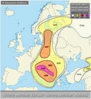
Outlook for tomorrow - Wednesday, July 30th, 2014. A severe weather outbreak appears likely across the central Mediterranean and W Balkans - a rare HIGH RISK has been issued along the E Adriatic sea! Conditons are supportive of numerous severe storms with excessive rainfall and tornadoes as primary threat! Locally, very high rainfall amounts and flash floods are expected.
*** A severe weather outbreak appears likely across the Adriatic sea and surropunding areas. Starting in early morning from the north and spreading south during the day. All types of severe events are possible – the main threat is locally very heavy / excessive rainfall. ***
A powerful upper low will be moving across the central Mediterranean and serve as a focus for robust severe weather episodes. Another trough will be pushed east across the NW Europe with an associated frontal boundary from CNTRL Scandinavia into central Europe. A short-wave moves from E Scandinavia into NW Russia.
A HIGH risk has been issued for coastal areas of Adriatic sea inland into western Balkans and into parts of N Italy with threat for torrential excessive rainfall, tornadoes / waterspouts and lesser extent for severe winds and large hail. It appears likely that a severe weather outbreak will occur on Wednesday and locally dangerous flooding conditions are expected. As the upper low makes progress further SE into central Mediterranean, widespread storms and clusters should develop / maintain along the SE-wards moving cold front across E Adriatic sea onshore onto the Dynaric mountain range. Strong QG forcing combined with extremely unstable airmass and moderatelly strong deep layer shear / helicity within persisting strong southerly LL jet should result in organized severe storms where serious flash floods risk will exist due to combined strong orographic and convective rainfall. Very high amounts of rainfall (100-150mm/24h) locally are well possible. Further north towards N Italy, a stalled frontal boundary should act as a trigger of persisting maintaining cluster abd therefore high amount of rainfall is expected as well.


